When Fungimap commenced in the mid 1990s, records submitted were stored at first in spreadsheets and then in the “Fungimap database”, an Access database maintained at Royal Botanic Gardens Victoria. There was no on-line interface for this database but the records were used to create the maps for Fungi Down Under, when it was published in 2005.
With the advent of the Atlas of Living Australia (ALA), the portal provided by the ALA provided a window into data aggregated from a variety of contributors, including Fungimap and reference collections such as fungaria and herbaria.
Fungimap data has not been supplied to the ALA for some years, but with assistance from the Field Naturalists Club of Victoria Environment Fund, data supply to the ALA is now up-to-date.
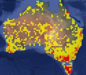
The density map below is based on records currently in the Fungimap database (not including iNaturalist records, see below). Even with more than 100,000 records, there are plenty of spots around Australia where recorders can fill blanks in distributions! Even near larger cities, which is where most records come from, there are under-recorded grids.
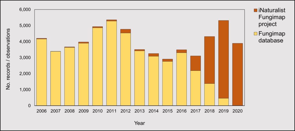
There has been an enthusastic take-up of iNaturalist by Fungimappers, and the iNaturalist Fungimap project is now one of the largest projects on iNaturalist covering a group of Australian biota (total records to date more than 29,300). The graph below shows the successful transition to iNaturalist. The overall recording rate is more or less steady, in the range 3000 to 5000 records per year.
We encourage Fungimappers to continue to submit their observations through iNaturalist, as this facilitates submission of geo-referenced images as well as curation of the observations by a wide range of experts. There is a dedicated Fungimap Australia project within iNaturalist and research grade observation are provided to the ALA on a regular basis.
We’ll continue to maintain the Fungimap database for the moment. There remain some recent records yet to be entered into the Fungimap database, especially from paper-based observations, and work continues on databasing these records. An updated set of the records in the Fungimap database will now be supplied to the ALA approximately every six months.
Due to some glitches in a previous data transfer, there are several thousand Fungimap records sitting in the ocean that are corrupted “rogue” records. The uncorrupted records are mapped to the correct location. We are working with the ALA to remove these records.
Also as part of the data clean up, we’ve tested the option to include the recorders name. Previously all Fungimap records were sent to the ALA with only the recorder number (used internally to track recorders in the Fungimap database). Just let us know if you’d like your name used when data from the Fungimap database is supplied to the ALA. If you are using iNaturalist, you get to choose what name you wish to associate with your records: whether your full name, or a nickname.
Processing records, cleaning up data and providing it to the ALA has been a team effort, and we particularly thank volunteers Caine Barlow, Graham Patterson and Wendy Cook along with Tom May at RBG Victoria and Fungimap Coordinator Cameron Durnsford; along with the FNCV Environment Fund.
Please direct any questions about data and mapping to fungimapids@gmail.com